Model Building in Natural Environments

Introduction

This work deals with the development of the use of a video camera in order to add useful information for both localization and navigation of a mobile robot roving in natural environments.

The line of research in perception for mobile robot are basically focused on 3-D information, obtained by a laser ranger finder or a stereoscopic system. However, depth information is not enough to get a complete description of the environment. Other information such as the nature of the elements presents in the scene have to be taken into account.

Our approach

We are using the Earth Mover's Distance as an environment recognition method, in such a way and appropriate data base is found making it easier to label extracted regions by a reduced number of classes and allowing to make inferences from contextual information. Involving this information helps controlling the decision making process required to correctly identify natural objects and to describe natural scenes. In order to achieved the scene interpretation in a single image, we have proposed the following approach. This one consists in several phases executed in sequence and the cooperation among them is possible. The result of the previous phase could be checked by the current phase and if it is necessary corrected.

The principal phases of the approach are:
  • region extraction: firstly, the color image is segmented to obtain the principal regions of the scene.
  • region characterization: each region of the scene is characterized by its color and its texture.
  • region identification: the nature (class) of the elements (regions) in the scene is obtained by comparing a vector of features with a database composed by different classes, issued from a learning process. After that, the regions having the same nature are merged and the consistency of the results are verified by using context.
  • Experiments


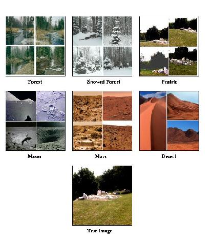
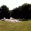
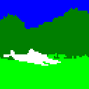
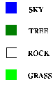
    Environment recognition
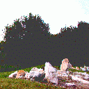
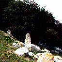
    The following images show the outdoor experimental site of outdoor robots at the LAAS-CNRS.

    Original Images Segmented and classified images Class


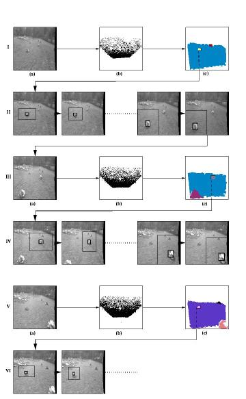
    A vision system for outdoor robot navigation

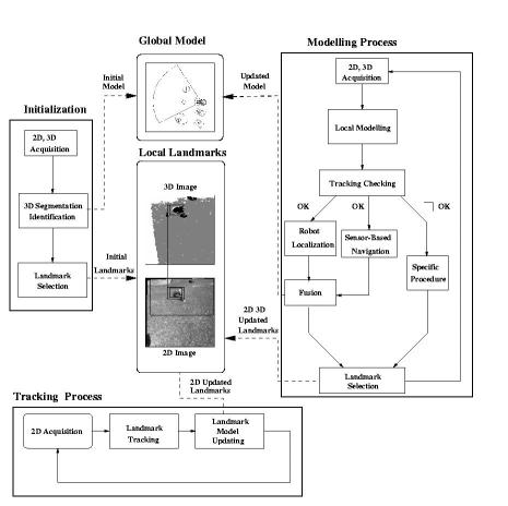
    Environment Modeling


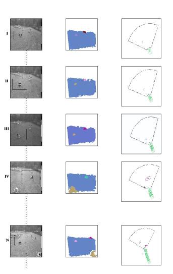
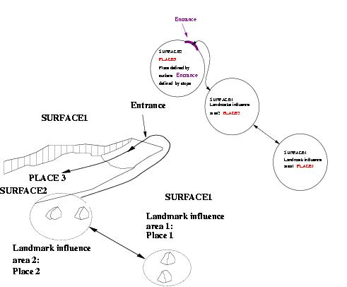
    Robot visual navigation based on landmarks Simultaneous Localization and Modeling (SLAM)

    Publications

  • Local Reference Frames vs. Global Reference Frame for Mobile Robot Localization and Path Planning, M. Alencastre-Miranda, L. Munoz-Gomez, R. Murrieta-Cid and R. Monroy. Proceedings of the Special Session of the 5th Mexican International Conference on AI, MICAI 2006,IEEE Computer Society Press , pages 309-318, Mexico, 2006.
  • A Hybrid Segmentation Method Applied to Color Images and 3D Information, Rafael Murrieta-Cid and Raul Monroy. (MICAI'06), Lecture Notes in Artificial Intelligence 4293, Pages 789-799, A. Gelbukh and C. A. Reyes Eds, Springer-Verlag 2006
  • Visual Navigation in Natural Environments: From Range and Color Data to a Landmark-based Model, R. Murrieta-Cid, C. Parra, M. Devy. Journal Autonomous Robots Vol. 13 no 2 pp. 143-168
  • A Vision System for Environment Representation: From Landscapes to Landmarks, R. Murrieta-Cid, C. Parra, M. Devy, B. Tovar, C. Esteves. (MICAI'02). Lectures Notes in Artificial Intelligence, Vol 2313, Springer-Verlag Eds
  • Road Detection for Robot Navigation, G. Avina, Michel Devy and R. Murrieta-Cid. In Proc of International Symposium on Robotics and Automation (ISRA'02), 2002
  • Building Multi-level Models: From Landscapes to Landmarks, R. Murrieta-Cid, C. Parra, M. Devy, B. Tovar, C. Esteves. In Proc IEEE International Conference on Robotics and Automation, ICRA'02, 2002
  • Scene modeling from 2D and 3D sensory data acquired from natural enviroments, R. Murrieta-Cid, C. Parra, M. Devy and M. Briot. In Proc of 10th International Conference on Advanced Robotics, ICAR'01, 2001
  • Preliminary results on the use of stereo, color cameras and laser sensors in Antarctica, N. Vandapel, S. Moorehead, W. Whittaker, R. Chatila and R. Murrieta-Cid. (ISER'99), Lecture Notes in Control and Information Sciences 250, Eds, P. Corke, J. Trevelyan, Springer.
  • Contribution on vision and modeling for outdoor robotics in natural scenes R. Murrieta-Cid, C. Parra, M. Devy and M. Briot, In Proc of International Symposium on Robotics and Automation (ISRA'98), 1998
  • 3-D modeling and robot localization from visual and range data in natural scenes, C. Parra, R. Murrieta-Cid, C. Parra, M. Devy and M.Briot (ICVS'99). Lecture Notes in Computer Science 1542, Springer H.I. Christensen Ed., pages 450-468
  • Landmark identification and tracking in natural environment, R. Murrieta-Cid, M. Briot and N. Vandapel. In proc IEEE/RSJ-International Conference on Intelligent Robots and Systems IROS'98
  • Le Modele Nominatif de Régions: segmentation couleur et identification de régions par analyse de couleur et de texture, P. Lasserre and R. Murrieta Cid and M. Briot, In proc Sixteenth Gretsi Symposium on Signal and Images Processing, 1997
  • Color segmentation in principal regions for natural outdoor scenes, R. Murrieta-Cid and P. Lasserre and M. Briot, In proc Third Workshop on Electronic Control and Measuring Systems, Toulouse, 1997
  • Vision pour la robotique mobile d'extérieur : identification de régions par des critéres de texture, R. Murrieta-Cid, Rapport de DEA ENSEEIHT-INPT, 1995
  • Links to similar research

  • Automatic Image Classification at The Bristol University Image Processing and Computer Vision Group
  • Image classification at Berkeley Digital Library Project
  • Back to the main page
    Nicolas Vandapel
    Modificado: Tue Mar 3 11:59:05 2009, por: Rafael Eric Murrieta Cid